A Bridge on Economic Issues between China and the World


 Facebook
  Twitter
  Instagram
 WeChat
  Email
Email When History Matters Little: Political Hierarchy and Regional Development in China, AD 1000-2000

Regime changes in China between AD 1000 and 2000 systematically altered the relative importance of different regions in the political hierarchy of that time. The evolution of Chinese provincial capitals and economic activities during this period throws light on how political factors shape economic geography. Employing a panel dataset across 261 prefectures, we find that while a prefecture definitely benefits from gaining provincial capital status in terms of population density and urbanization, the economic advantage of provincial capital prefectures shrinks greatly after losing capital status — implying that a prestigious past does not always matter for current local development. This finding differs from a large body of literature concerning path dependence. To understand the underlying factors, we document that not only public offices but also important production factors such as human capital and transportation networks alter their geographical location with the change in provincial capital status, which suggests that: 1) We cannot simply consider provincial capitals as consumption-intensive “parasite cities”; and 2) The state can play a critical role in overcoming the inertia in the location of economic activity through providing infrastructure.
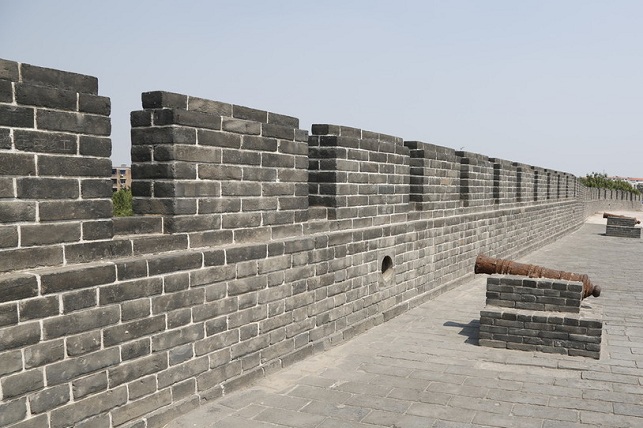
In AD 1000, the city of Kaifeng was the most prosperous city in China and, with an estimated population of 1 million, arguably the largest city in the world. By 2015, however, its GDP ranks 129th among Chinese cities and its former glory is long forgotten. Kaifeng's decline is closely related to its status in the political hierarchy having first lost political prestige as the national capital in the thirteenth century and then its status of provincial capital in the twentieth century. Kaifeng is just one of many cases whose economic status rises and falls with its position in the political hierarchy in China.
In Bai and Jia (2018), we attempt to understand this politico-economic link by tracing the evolution of provincial capitals and spatial distribution of economic activity in China from AD1000 to 2000. By documenting the changes in economic activity, we complement existing literature focusing on the persistence in economic activity due to locational fundamentals (pioneered by Davis and Weinstein 2002) or the persistent impacts of temporary advantages (exemplified in Bleakley and Lin 2012). By exploiting changes in political status and uncovering some mechanisms, we extend the research relying on cross-sectional variation to understand how politics shapes economic geography (e.g., De Long and Shleifer 1993). Moreover, by investigating when history matters little, we can also better understand why history matters (see Nunn 2009 for an overview): whether the state (or another player) has incentives and capacity to overcome the inertia in the location of economic activity is an important predictor for whether history matters.
Regime Changes and Provincial Capital Relocation
As the largest enduring state with a distinctive political hierarchy, China provides a particularly advantageous context to understand how politics affect economic geography. On the one hand, China underwent six dynastic regime changes during AD1000-2000 that brought about drastic shifts in boundaries and centers of power, with national capitals relocated five times and the method for dividing provinces amended from replying on natural geographical barriers (known as “suiting [i.e., following] the forms of mountains and rivers” to intentionally including the natural barriers within provinces so that boundaries “interlocked like dog's teeth”. Consequently, 63 out of the 261 prefectures defined by the 2000 boundaries were once a provincial capital whose status changed with a new regime. On the other hand, despite regime changes, China's political hierarchical system remained surprisingly stable, where the central government in each regime ruled the vast country by using a three-tier administrative system (province-prefecture-county) and monopolizing the power of appointing, reshuffling and removing local officials for each tier. Thanks to the enduring administrative system, China has a long history of governmental censuses whose rich information on population, geography, infrastructure, and bureaucracy allow us to trace the changes in capital status, construct extensive prefecture-level data over time, and examine how both gaining and losing importance in the political hierarchy matters for a prefecture’s development.
The Political Logic of Provincial Capital Location
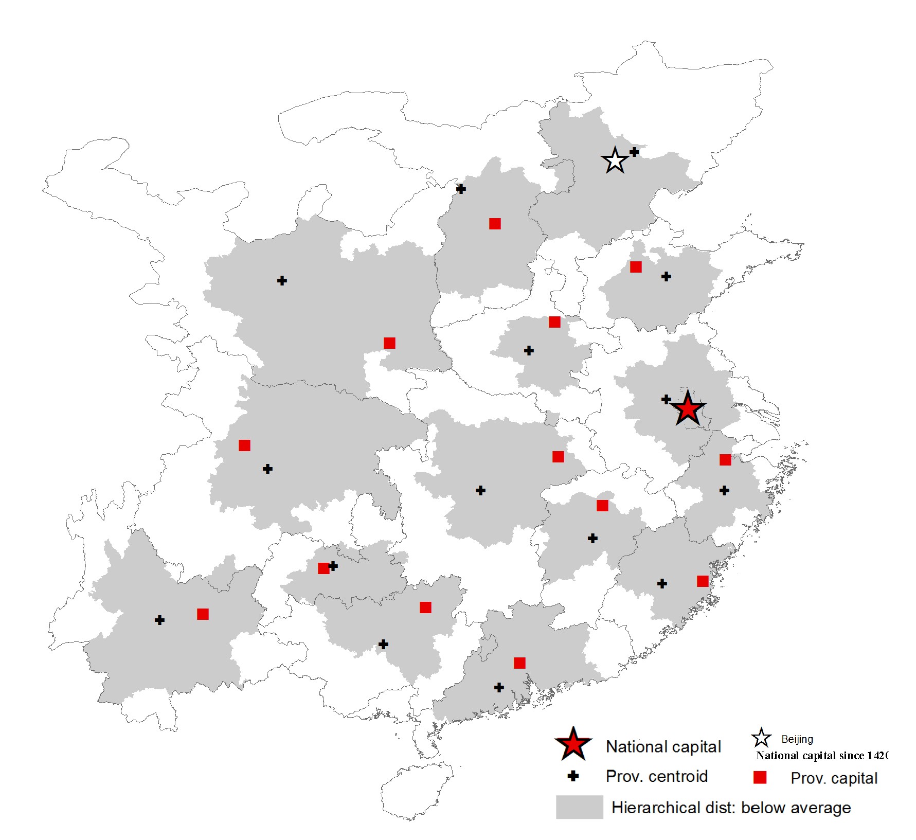
Provincial capitals serve two important roles: they are (1) administrative centers for provincial affairs, and (2) important nodes through which the central government connect with large number of localities throughout the country to collect/distribute resources and information. Two costs thus become important for the location of a capital for a province: the cost of collecting resources and information within a province and that of delivering some part of them to the national center. We then define the weighted sum of the two distances as “hierarchical distance” and show a prefecture's rank in hierarchical distance within a province to be a strong predictor of its capital status.
Intuitively, the algorithm of hierarchical distance implies that the provincial capitals deviate from the provincial centroid toward the direction of the national capital. To see this logic, we map the location of provincial capitals regime-by-regime. Figure 1 presents the Ming dynasty as an example to illustrate the logic.
The Importance of Gaining and Losing Provincial Capital Status
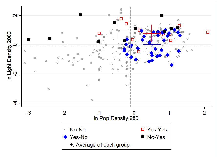
As a descriptive pattern, we first look at the 980 and 2000 data, a two-period structure that allows us to depict the main pattern by categorizing the prefectures into four groups: (1) capitals in both periods, denoted by “yes-yes”, (2) capitals in 980 but not in 2000, denoted by “yes-no”, capitals in 2000 but not in 980, denoted by “no-yes”, and (4) not capitals in either period, denoted by “no-no”.
In Figure 2, the x-axis indicates the standardized logged population density in 980, while the y-axis indicates the standardized logged night light density in 2000. The data reveal systematic changes as indicated by the four crosses in Figure 2:
• An average “no-yes” prefecture was 0.3 standard deviations below the mean in 980 yet transitioned to one standard deviation above the mean in 2000, indicating that gaining capital status is correlated with better economic development.
• An average “yes-no” prefecture was 0.5 standard deviations above the mean and comparable to a “yes-yes” prefecture in 980 (when both were provincial capitals), but it nears the mean and is similar to a “no-no” prefecture in 2000 after losing capital status (i.e., its capital status in 980 does not determine its level of economic development in 2000).
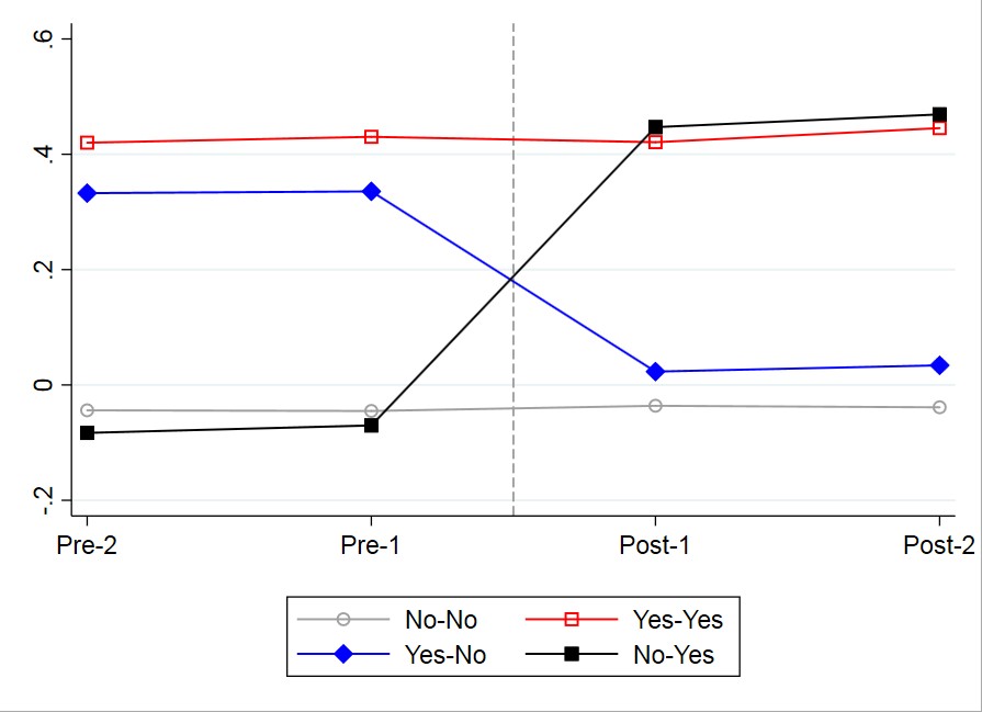
Analogous to the analysis above, we can divide the prefectures into four groups every two regimes. This way, we can further visualize the four groups period by period. To compare prefectures with similar characteristics, we first regress the log population density on all of the prefecture characteristics — its geographical variables, including whether a prefecture contains a plain or major river or is on the coast, as well as its slope, elevation, longitude, and latitude, its agricultural variables, including five types of crop suitability, and its macroregion dummies — and obtain the residuals. We then plot the average residuals for the four groups period-by-period (relative to the time of status change) in Figure 3, which again shows systematic changes:
• The gaining group (i.e., the “no-yes”) is similar to its “no-no” peer group before the status change, but it becomes 48 percent higher than its “no-no” peer group after gaining capital status;
• The losing group (i.e., the “yes-no”) is about 38 percent higher than its “no-no” peer group before the status change, but it becomes comparable to the “no-no” peer group after losing capital status.
In Bai and Jia (2018), we examine these patterns more systematically using three approaches: difference-in-differences analysis, an instrument variable approach guided by the algorithm mentioned above, and a matching method.
Underlying Factors
What, then, explains the link between political hierarchy and regional economic development? Many factors change along with a prefecture’s political status. Because it is difficult to enumerate each factor in history and the current age, we focus on certain factors guided by answering two questions important for interpreting our findings. First, is our finding purely driven by public employment (and possible multiplier)? The answer to this question has implications on whether we can consider the provincial capitals as consumption-intensive “parasite cities.” Second, since fixed costs are important for explaining path dependence, is there any evidence that some player incurs the fixed costs? We find that public employment is indeed part of the channels; however, we also demonstrate that important production factors — such as human capital (measured by the number of individuals who are successful in the imperial exams in the historical context and those with a high school level of education and above in 2000) and transportation networks (built by the state) are also affected. Specifically, we observe a systematic rise and fall in a region's human capital and its centrality in the transportation networks after the gaining and losing of capital status. The finding on transportation networks also illustrates that the state can play a critical role in overcoming the inertia by providing important infrastructure.
Concluding Remarks
A combination of an enduring state, a distinctive political hierarchy, and many changes in national and provincial capitals make China a particularly advantageous context for examining the link between politics and economic geography. Given that the first-tier cities in today's China are typically provincial capitals, it is perhaps not an exaggeration to claim that political hierarchy shapes the country’s urban hierarchy.
The existing literature on path dependence has provided us abundant examples in showing that history matters. Yet, we also observe changes in economic activity in many contexts, not only in terms of regional development but also in terms of industrial location within and across countries. In this paper, by documenting when history matters little, we actually can better understand why history matters. History would matter more if the state lacked the incentives to relocate the capitals; for instance, if China were so small and homogeneous that the choice of capitals mattered little or if the state lacked the capacity even if it had the incentive to relocate economic activity. We hope that such a perspective is useful in interpreting persistence and changes in different contexts.
Bai, Y., and R. Jia (2018), “When History Matters Little: Political Hierarchy and Regional Development in China, AD1000-2000”, Working Paper, The Chinese University of Hong Kong and the University of California, San Diego.
Bleakley, H., and J. Lin (2012), “Portage and Path Dependence,” Quarterly Journal of Economics 127(2): 587-644.
Davis, D., and D. Weinstein (2002), “Bones, Bombs, and Break Points: The Geography of Economic Activity,” American Economic Review 92(5): 1269-1289.
De Long, B., and A. Shleifer (1993), “Princes and Merchants: European City Growth before the Industrial Revolution,” Journal of Law and Economics 36(2): 671-702.
In AD 1000, the city of Kaifeng was the most prosperous city in China and, with an estimated population of 1 million, arguably the largest city in the world. By 2015, however, its GDP ranks 129th among Chinese cities and its former glory is long forgotten. Kaifeng's decline is closely related to its status in the political hierarchy having first lost political prestige as the national capital in the thirteenth century and then its status of provincial capital in the twentieth century. Kaifeng is just one of many cases whose economic status rises and falls with its position in the political hierarchy in China.
In Bai and Jia (2018), we attempt to understand this politico-economic link by tracing the evolution of provincial capitals and spatial distribution of economic activity in China from AD1000 to 2000. By documenting the changes in economic activity, we complement existing literature focusing on the persistence in economic activity due to locational fundamentals (pioneered by Davis and Weinstein 2002) or the persistent impacts of temporary advantages (exemplified in Bleakley and Lin 2012). By exploiting changes in political status and uncovering some mechanisms, we extend the research relying on cross-sectional variation to understand how politics shapes economic geography (e.g., De Long and Shleifer 1993). Moreover, by investigating when history matters little, we can also better understand why history matters (see Nunn 2009 for an overview): whether the state (or another player) has incentives and capacity to overcome the inertia in the location of economic activity is an important predictor for whether history matters.
Regime Changes and Provincial Capital Relocation
As the largest enduring state with a distinctive political hierarchy, China provides a particularly advantageous context to understand how politics affect economic geography. On the one hand, China underwent six dynastic regime changes during AD1000-2000 that brought about drastic shifts in boundaries and centers of power, with national capitals relocated five times and the method for dividing provinces amended from replying on natural geographical barriers (known as “suiting [i.e., following] the forms of mountains and rivers” to intentionally including the natural barriers within provinces so that boundaries “interlocked like dog's teeth”. Consequently, 63 out of the 261 prefectures defined by the 2000 boundaries were once a provincial capital whose status changed with a new regime. On the other hand, despite regime changes, China's political hierarchical system remained surprisingly stable, where the central government in each regime ruled the vast country by using a three-tier administrative system (province-prefecture-county) and monopolizing the power of appointing, reshuffling and removing local officials for each tier. Thanks to the enduring administrative system, China has a long history of governmental censuses whose rich information on population, geography, infrastructure, and bureaucracy allow us to trace the changes in capital status, construct extensive prefecture-level data over time, and examine how both gaining and losing importance in the political hierarchy matters for a prefecture’s development.
The Political Logic of Provincial Capital Location
Provincial capitals serve two important roles: they are (1) administrative centers for provincial affairs, and (2) important nodes through which the central government connect with large number of localities throughout the country to collect/distribute resources and information. Two costs thus become important for the location of a capital for a province: the cost of collecting resources and information within a province and that of delivering some part of them to the national center. We then define the weighted sum of the two distances as “hierarchical distance” and show a prefecture's rank in hierarchical distance within a province to be a strong predictor of its capital status.
Intuitively, the algorithm of hierarchical distance implies that the provincial capitals deviate from the provincial centroid toward the direction of the national capital. To see this logic, we map the location of provincial capitals regime-by-regime. Figure 1 presents the Ming dynasty as an example to illustrate the logic.
Figure 1: Hierarchical Distance and Location of Provincial Capitals in the Ming Dynasty
The Importance of Gaining and Losing Provincial Capital Status
As a descriptive pattern, we first look at the 980 and 2000 data, a two-period structure that allows us to depict the main pattern by categorizing the prefectures into four groups: (1) capitals in both periods, denoted by “yes-yes”, (2) capitals in 980 but not in 2000, denoted by “yes-no”, capitals in 2000 but not in 980, denoted by “no-yes”, and (4) not capitals in either period, denoted by “no-no”.
In Figure 2, the x-axis indicates the standardized logged population density in 980, while the y-axis indicates the standardized logged night light density in 2000. The data reveal systematic changes as indicated by the four crosses in Figure 2:
• An average “no-yes” prefecture was 0.3 standard deviations below the mean in 980 yet transitioned to one standard deviation above the mean in 2000, indicating that gaining capital status is correlated with better economic development.
• An average “yes-no” prefecture was 0.5 standard deviations above the mean and comparable to a “yes-yes” prefecture in 980 (when both were provincial capitals), but it nears the mean and is similar to a “no-no” prefecture in 2000 after losing capital status (i.e., its capital status in 980 does not determine its level of economic development in 2000).
Figure 2: Population Density in 980 vs. Night Light Density in 2000
Analogous to the analysis above, we can divide the prefectures into four groups every two regimes. This way, we can further visualize the four groups period by period. To compare prefectures with similar characteristics, we first regress the log population density on all of the prefecture characteristics — its geographical variables, including whether a prefecture contains a plain or major river or is on the coast, as well as its slope, elevation, longitude, and latitude, its agricultural variables, including five types of crop suitability, and its macroregion dummies — and obtain the residuals. We then plot the average residuals for the four groups period-by-period (relative to the time of status change) in Figure 3, which again shows systematic changes:
• The gaining group (i.e., the “no-yes”) is similar to its “no-no” peer group before the status change, but it becomes 48 percent higher than its “no-no” peer group after gaining capital status;
• The losing group (i.e., the “yes-no”) is about 38 percent higher than its “no-no” peer group before the status change, but it becomes comparable to the “no-no” peer group after losing capital status.
In Bai and Jia (2018), we examine these patterns more systematically using three approaches: difference-in-differences analysis, an instrument variable approach guided by the algorithm mentioned above, and a matching method.
Figure 3: Pooling All Changes Together
What, then, explains the link between political hierarchy and regional economic development? Many factors change along with a prefecture’s political status. Because it is difficult to enumerate each factor in history and the current age, we focus on certain factors guided by answering two questions important for interpreting our findings. First, is our finding purely driven by public employment (and possible multiplier)? The answer to this question has implications on whether we can consider the provincial capitals as consumption-intensive “parasite cities.” Second, since fixed costs are important for explaining path dependence, is there any evidence that some player incurs the fixed costs? We find that public employment is indeed part of the channels; however, we also demonstrate that important production factors — such as human capital (measured by the number of individuals who are successful in the imperial exams in the historical context and those with a high school level of education and above in 2000) and transportation networks (built by the state) are also affected. Specifically, we observe a systematic rise and fall in a region's human capital and its centrality in the transportation networks after the gaining and losing of capital status. The finding on transportation networks also illustrates that the state can play a critical role in overcoming the inertia by providing important infrastructure.
Concluding Remarks
A combination of an enduring state, a distinctive political hierarchy, and many changes in national and provincial capitals make China a particularly advantageous context for examining the link between politics and economic geography. Given that the first-tier cities in today's China are typically provincial capitals, it is perhaps not an exaggeration to claim that political hierarchy shapes the country’s urban hierarchy.
The existing literature on path dependence has provided us abundant examples in showing that history matters. Yet, we also observe changes in economic activity in many contexts, not only in terms of regional development but also in terms of industrial location within and across countries. In this paper, by documenting when history matters little, we actually can better understand why history matters. History would matter more if the state lacked the incentives to relocate the capitals; for instance, if China were so small and homogeneous that the choice of capitals mattered little or if the state lacked the capacity even if it had the incentive to relocate economic activity. We hope that such a perspective is useful in interpreting persistence and changes in different contexts.
(Ying Bai, The Chinese University of Hong Kong, and Ruixue Jia, University of California, San Diego.)
Bai, Y., and R. Jia (2018), “When History Matters Little: Political Hierarchy and Regional Development in China, AD1000-2000”, Working Paper, The Chinese University of Hong Kong and the University of California, San Diego.
Bleakley, H., and J. Lin (2012), “Portage and Path Dependence,” Quarterly Journal of Economics 127(2): 587-644.
Davis, D., and D. Weinstein (2002), “Bones, Bombs, and Break Points: The Geography of Economic Activity,” American Economic Review 92(5): 1269-1289.
De Long, B., and A. Shleifer (1993), “Princes and Merchants: European City Growth before the Industrial Revolution,” Journal of Law and Economics 36(2): 671-702.
Nunn, N. (2009), “The Importance of History for Economic Development,” Annual Review of Economics 1(1): 65-92.

Latest
Most Popular
- VoxChina Covid-19 Forum (Second Edition): China’s Post-Lockdown Economic Recovery VoxChina, Apr 18, 2020
- China’s Great Housing Boom Kaiji Chen, Yi Wen, Oct 11, 2017
- China’s Joint Venture Policy and the International Transfer of Technology Kun Jiang, Wolfgang Keller, Larry D. Qiu, William Ridley, Feb 06, 2019
- The Dark Side of the Chinese Fiscal Stimulus: Evidence from Local Government Debt Yi Huang, Marco Pagano, Ugo Panizza, Jun 28, 2017
- Wealth Redistribution in the Chinese Stock Market: the Role of Bubbles and Crashes Li An, Jiangze Bian, Dong Lou, Donghui Shi, Jul 01, 2020
- Evaluating Risk across Chinese Housing Markets Yongheng Deng, Joseph Gyourko, Jing Wu, Aug 02, 2017
- What Is Special about China’s Housing Boom? Edward L. Glaeser, Wei Huang, Yueran Ma, Andrei Shleifer, Jun 20, 2017
- Privatization and Productivity in China Yuyu Chen, Mitsuru Igami, Masayuki Sawada, Mo Xiao, Jan 31, 2018
- How did China Move Up the Global Value Chains? Hiau Looi Kee, Heiwai Tang, Aug 30, 2017
- China’s Shadow Banking Sector: Wealth Management Products and Issuing Banks Viral V. Acharya, Jun Qian, Zhishu Yang, Aug 09, 2017


